


Craig Hunter
For outdoor professionals including surveyors, engineers, and pilots, alongside advanced enthusiasts requiring precise geodetic and meteorological data.
 Pro Altimeter for Watch













Snapshot
Who is Craig Hunter?
High-precision navigation and meteorological tools for outdoor professionals and technical enthusiasts.
Target audience


Portfolio
Free 3Last updated

Pro Altimeter for Watch
v5.6.02
1.1y ago
Publisher DNA
What defines Craig Hunter?
Publisher DNA
Primary focus
Professional-grade navigation and weather instrumentation
Scale
indie
Target audience
Outdoor professionals including surveyors, engineers, and pilots, alongside advanced enthusiasts requiring precise geodetic and meteorological data.
Origin
Founded and operated by Dr. Craig Hunter, a NASA-awarded aerospace engineer with over 35 years of software development experience.
Signature Patterns
- •Heavy emphasis on high-fidelity sensor integration including barometric, GPS, and magnetic data
- •Technical, data-dense user interfaces designed for field utility rather than casual use
- •Mixed monetization strategy utilizing both paid-upfront and free utility models
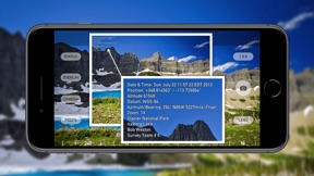
- •Focus on professional-grade features like AR data overlays and geo-tagged media capture
- •Cross-platform deployment across iOS and watchOS with high data parity
Portfolio momentum
The publisher maintains a steady development cadence with 2 updates in the last 6 months and 62.5% of the portfolio remaining active.
Company profile
medium confidence- Employees
- 1-10
Portfolio
What does Craig Hunter ship?
Apps
9 apps analysed


Hardware-sensor integration provides high-fidelity data compared to GPS-only rivals
- Accurate barometric sensor calibration provides reliable altitude data for specialized outdoor and professional measurement tasks
- App crashes immediately upon launch following the latest update, preventing access to core altimeter functionality
Hunter Research brand reputation [Trust-based conversion]
- High satisfaction with core altimeter functionality during initial usage periods
- License verification failures prevent reinstallation after system updates on mobile devices


Single-market publisher, every app ships only to United States.
Based on 8 of 9 apps with localized market data, more coverage rolling in as scans complete · last scanned .
Americas (1)
- United States8 / 8
Core markets (8/8 apps)
User Sentiment
How do users feel about their apps?
3
Positive apps
0
Neutral / mixed
0
Negative apps
82/100
Avg sentiment score
Rivals
Who does Craig Hunter compete with?
The rivals identified
Nemeses(4)


Compass × functions as a general-purpose orientation utility that complements the specialized barometric focus of the source app.


Competes for the same outdoor navigation user base by consolidating multiple professional-grade instruments into one interface.


Both apps target outdoor enthusiasts with altitude tracking, but the rival captures the Apple Watch and CarPlay segments which Pro Altimeter lacks.


Both apps target outdoor enthusiasts with a $0.99 price point and offer Apple Watch functionality, creating direct competition for users seeking wrist-based navigation tools.
Contenders(25)

Both apps compete for the same navigation-focused user base, with Pro Compass targeting geodetic precision and the rival targeting general way-finding and religious orientation.


Both apps target outdoor enthusiasts with orientation and location data, creating direct competition for users seeking precise navigation tools.


Serves the same outdoor navigation audience as Pro Compass by prioritizing offline functionality for remote areas.


Both apps target users requiring orientation and location data, with Pro Compass offering specialized geodetic tools that the pre-installed Compass utility lacks.


Both apps target outdoor enthusiasts and hikers by utilizing device barometric sensors for altitude tracking. They compete directly for users seeking precise elevation data during outdoor activities.


Altimeter: Elevation, Compass operates in the same navigation space but lacks the specialized professional calibration tools found in the source app.


Both applications provide location-based navigation tools, though they serve distinct segments: Theodolite targets professional field surveying, while Live Earth Camera focuses on casual consumer exploration.


Compass & Altimeter targets the same outdoor demographic but uses an all-in-one dashboard approach that contrasts with the source app.


Both apps target hikers and outdoor enthusiasts by utilizing device barometric sensors for altitude tracking. They compete directly for users seeking reliable elevation data during mountain activities.


Both apps target outdoor navigation users, but Compass ⊘ captures the casual iPhone audience while Pro Compass for Watch focuses on Apple Watch users requiring specialized hardware-style tools.


Both apps target field professionals requiring precise GPS-tagged photo documentation for surveying and construction tasks. They compete directly for the same user base of engineers and field inspectors who rely on metadata-rich media for project verification.


Both apps target users seeking waypoint-based navigation, though Pro Compass for Watch focuses on hardware-style watch utility while Waypoint Nav emphasizes iPhone-based haptic feedback.


Both applications target outdoor navigation on Apple Watch, competing for the same hiker demographic despite differing feature sets.


Both applications target outdoor navigation on Apple Watch, with Pro Compass for Watch providing map-based visualization while Waypoint focuses on simple arrow-based offline navigation.


Both apps target users seeking digital navigation tools, with Full Compass providing multi-functional utility like altimeters and level gauges that overlap with the geodetic data requirements of Pro Compass.


Both apps target outdoor navigation and telemetry tracking at an identical 1.99 dollar price point.


Both applications target outdoor enthusiasts and professionals with paid navigation utilities priced at 1.99, creating direct competition for the same user segment.


Both apps target professionals and outdoor enthusiasts requiring precise geodetic location data and coordinate management tools.


Both applications target professional surveyors and outdoor field workers, creating direct competition for users requiring precise geographic data collection and measurement tools.


Accurate Compass competes for the same outdoor enthusiast audience by offering magnetic and true north tracking, directly overlapping with the core functionality of Pro Compass.


Both apps target Apple Watch users seeking navigation tools at the same $1.99 price point.


Both apps target outdoor navigation on Apple Watch, competing for the same user base seeking orientation tools for hiking and biking.


Both apps target outdoor enthusiasts with navigation tools, creating direct competition for users seeking orientation and location data.


Both applications target outdoor enthusiasts and professionals with paid navigation tools, competing directly for users seeking precise directional and positional data.


Both applications target outdoor navigation on Apple Watch, competing for the same user base seeking directional tools for hiking and orientation.
Same space(62)


Targets the same professional field-researcher audience with waypoint logging and offline reliability.


Provides a similar outdoor navigation utility as Pro Compass by integrating environmental data with a compass interface.


Targets the same professional field utility market as Pro Compass by offering specialized solar tracking and AR visualization.


Shares the navigation utility space with Pro Compass by providing precise trip logging and coordinate-based tracking.


Serves the same professional field-worker audience by providing offline mapping for remote surveying tasks.


Provides specialized mapping layers for field professionals, overlapping with Nav Camera's documentation utility.


Provides real-time tracking utilities for outdoor enthusiasts, overlapping with Nav Camera's data overlay functionality.


Functions as a specialized navigation tool for a specific directional need, similar to the compass features in Pro Compass.


Functions as a specialized telemetry and tracking tool for amateur radio operators, extending navigation into real-time station monitoring.

known for MapXplorer: Map Radar Navigate
Offers a GPS map camera feature similar to Nav Camera, though focused on consumer navigation and safety alerts.


Offers a specialized aviation tracking utility that uses hardware-specific interfaces to provide real-time flight data on the wrist.


Appeals to the same outdoor activity audience as Pro Compass by providing specialized trail and mountain navigation.


Targets the same geocaching and trekking audience as Pro Compass by providing multi-format coordinate support.


AeroAltitude competes for aviation professionals by providing density altitude calculations and airport database integration.


Offers a paid, offline-capable topographic mapping alternative for users who prefer one-time purchases over subscriptions.


Provides field guidance for agricultural professionals, mirroring the need for consistent navigation in remote areas.


This app offers topographic mapping for outdoor professionals, serving as a direct alternative to Theodolite's navigation suite.


OutDoors GPS France provides specialized topographic navigation for hikers, overlapping with Theodolite's outdoor professional use cases.


Altimeter+ offers a similar hybrid sensor approach for altitude tracking but focuses on a broader range of outdoor sports.


Bundles tactical navigation tools and survival manuals, serving as a comprehensive field reference for serious outdoor users.


Acts as a comprehensive location data tool that provides environmental metrics alongside standard compass functionality.


Walkmeter functions as a comprehensive fitness computer for users who require more data density than the source app.


Offers a similar digital compass and coordinate utility as Pro Compass for general outdoor navigation.


Altimeter GPS & Barometer focuses on wilderness and survival use cases, providing a specialized offline sensor-based alternative for remote environments.


Functions as a mobile chartplotter for marine professionals, sharing the need for precise location-based documentation.


Offers similar coordinate conversion and distance measurement tools as the geodetic features in Pro Compass.


Offers specialized marine navigation data that complements the source app's general orientation tools for water-based activities.


Travel Altimeter targets the same outdoor user base but focuses on casual hikers with battery-saving features rather than professional aviation precision.


CalTopo is a direct professional-grade alternative to Theodolite for backcountry terrain analysis and search-and-rescue operations.


It functions as a technical diagnostic tool for high-precision GPS hardware verification rather than a navigation aid.


My Altitude provides a similar navigation utility for outdoor enthusiasts but relies on ad-supported monetization instead of the paid model.


Hunting Points offers rural field navigation and property boundary identification, overlapping with Theodolite's land-surveying utility.


This app provides tactical situational awareness by integrating with existing training and operational workflows for teams.


Serves marine professionals who require high-precision bathymetric data for navigation and documentation.


Altimeter targets the same outdoor demographic with a broader set of environmental tools including weather forecasts and SOS features.


This app captures outdoor explorers through a global network of community-hidden containers that creates a physical-digital hybrid experience.


Targets the same outdoor navigation audience as Pro Compass by providing offline mapping for backcountry use.


Enables private, ad-free track recording and waypoint management for users who prioritize data ownership and GPX compatibility.


Pressure Altimeter provides a similar sensor-driven approach to altitude tracking for outdoor enthusiasts but lacks the specialized aviation-grade calibration.


Provides similar coordinate tracking and accuracy monitoring as the geodetic tools in Pro Compass.


Offers real-time tracking for logistics professionals, sharing the need for precise speed and distance monitoring.


Speedo focuses on vehicle performance logging, providing a specialized utility that complements Theodolite's broader navigation capabilities.


Provides a similar range of coordinate conversion and mapping tools as the geodetic features in Pro Compass.


Appeals to the same professional field navigation audience as Pro Compass by offering military-grade coordinate support.


My Altitude and Elevation GPS targets professional users with coordinate formats like MGRS and UTM, creating a more technical alternative.


Targets the same field professional audience as Pro Compass by providing coordinate conversion for inter-agency communication.


onX Hunt is a major competitor for land-boundary data, serving as a primary navigation tool for the same professional field audience.


Offers a privacy-centric alternative for drivers, contrasting with Nav Camera's data-rich documentation focus.


OS Maps provides community-rated trail discovery that complements Theodolite's professional-grade navigation for outdoor enthusiasts.


Outmap targets the backcountry navigation niche, offering 3D terrain visualization that competes with Theodolite's AR-based field tools.


It enables phone-free navigation by allowing users to sync routes and navigate offline directly on the watch.


Integrates augmented reality and camera views to provide a unique bearing navigation experience for land and sea.


Targets the same professional surveying and real estate audience with parcel-level mapping data.


Serves the same professional and recreational coordinate conversion market as Pro Compass.


GPS - Way Home Finder offers a minimalist, offline-first navigation alternative for users who prefer air-line arrows over maps.


Offers a global offline mapping solution for travelers, providing a more robust spatial context than the source app's waypoint manager.


Serves the same professional navigation audience as Pro Compass by providing high-precision offline calculations.


Gaia GPS targets the same backcountry professional niche as Theodolite, focusing on high-fidelity GIS data for remote environments.


Serves the same outdoor and military-grade navigation audience as Pro Compass by providing multi-system GNSS support.


Targets the same professional field worker audience as Pro Compass by focusing on precise coordinate translation.


what3words provides a precise location-identification system that acts as a supplementary tool for Theodolite's coordinate-based navigation.


Simplifies directional navigation by focusing on persistent pointers to specific locations, complementing the source app's waypoint manager.
New entrants(2)


Combines GPS photography and mapping, directly overlapping with Nav Camera's core media capture utility.


Offers a similar coordinate conversion utility as Pro Compass, focusing on offline reliability for field users.
The Analyst's Read
The bottom line on Craig Hunter
Bottom line
Hunter Research & Technology is a highly specialized indie operation that dominates the professional navigation niche through technical excellence and engineering-led design. Their weighted 4.47★ rating across a decade-old portfolio signals exceptional product-market fit and long-term reliability in the utility category.
Frequently asked questions
How many apps does Craig Hunter publish?
What kind of apps does Craig Hunter make?
What is Craig Hunter's top app?
In how many countries are Craig Hunter's apps available?
What fed this analysis
- Apps analyzed:
- 8
- With full intel:
- 0
- With overview:
- 8
- Website scraped:
- yes
- Social presence:
- yes